Stop Flying Blind on Your Jobsite.
Why construction crews across Northern Colorado are ditching the guesswork and letting drones do the heavy lifting.
Construction is brutal. Deadlines slip, budgets blow up, stakeholders call at the worst times, and somehow you're expected to have eyes on everything at once. Out here in Northern Colorado, the pace isn't slowing down and neither is the pressure on your team.
Whether you're running a ground-up build in Fort Collins, managing a civil project in Loveland, or overseeing development pushing into Timnath and Windsor, the story tends to be the same: too many unknowns, not enough visibility, and zero room for expensive surprises.
That's exactly where a drone data partner like Airborne Insight changes the game. We're not just flying cool aircraft around your jobsite we're delivering the kind of actionable, accurate data that keeps your project on track, your stakeholders happy, and your liability exposure way, way down.
Let's get into it.
The Real Pain Points Slowing You Down
Before we talk solutions, let's call out the stuff that keeps PMs, GCs, and site supers up at night:
😤 Schedule Slippage You don't catch delays until they've already cascaded. By the time someone flags it, you're weeks behind.
📋 Stakeholder Overload Owners, investors, and engineers all want updates and "trust me it's fine" stopped working a long time ago.
⚖️ Liability Exposure Disputes over existing conditions, site changes, or earthwork volumes can get ugly fast without solid documentation.
📐 Inaccurate Quantity Estimates Cut/fill, stockpile volumes, material tracking winging these numbers is expensive, full stop.
🏗️ Siloed Teams Field crews, office PMs, engineers, and owners are all working off different often outdated info.
👀 Limited Site Visibility You can't be everywhere at once. And walking the site only shows you what's eye level.
Sound familiar? Good. Because every single one of these is solvable and drones are a big part of how the sharpest construction teams in Northern Colorado are solving them right now.
"Drone data isn't a luxury anymore. It's the difference between managing your project and reacting to it."
How Airborne Insight Plugs Into Your Operation
Here's the thing we're not selling you a drone flight. We're selling you data you can actually use. Here's what that looks like in practice:
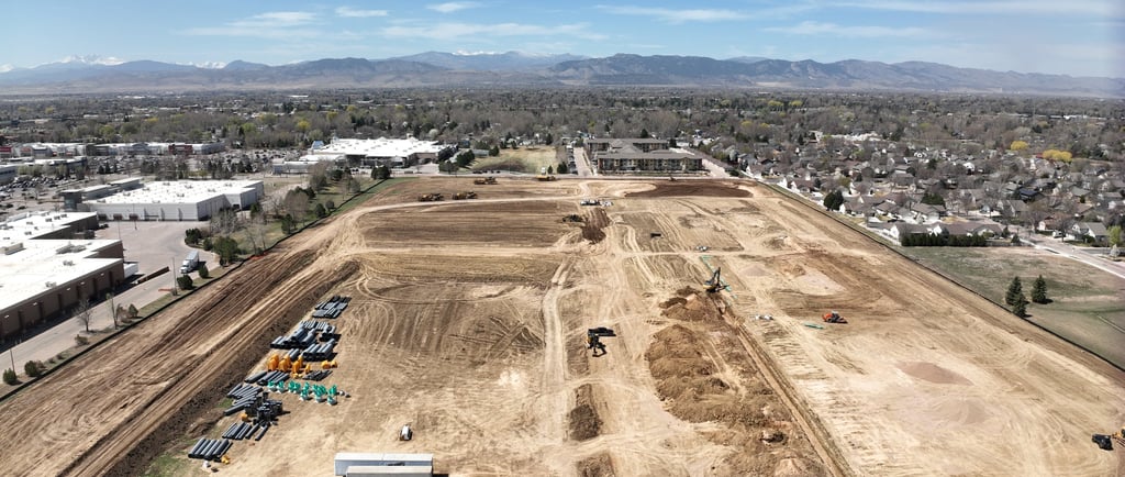
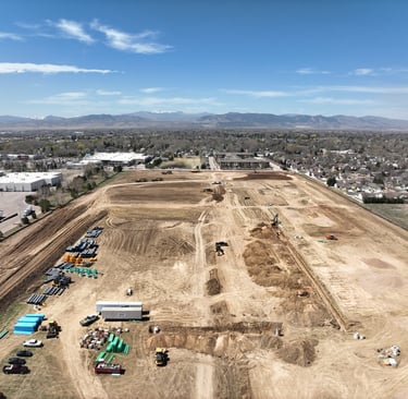
🗺️ Orthomosaic Maps & Progress Monitoring High-resolution, georeferenced site maps captured on a regular cadence. Everyone from your PM in the Fort Collins office to the engineer reviewing plans remotely can see exactly where things stand. No more "what does it look like out there?" calls. Just real, current data.
📦 Volumetric Reporting Forget walking a stockpile with a measuring tape. We give you precise cut/fill calculations and material volume reports that hold up to scrutiny. Whether you're reconciling with a sub or justifying a change order, the numbers are defensible.
📸 Aerial Documentation & 3D Modeling Every flight builds a visual and spatial record of your site. That documentation is gold when a dispute arises, a subcontractor claims something was "always like that," or an owner questions progress. You've got the receipts.
👥 Stakeholder-Ready Deliverables We don't just hand you raw data and wish you luck. Our outputs are clean, polished, and ready to drop into your next owner meeting, investor update, or project report. Stakeholders stay informed. You stay in control.
The Numbers Don't Lie
✅ 75% faster site data vs. traditional methods ✅ Fewer disputes with documented site conditions ✅ 100% site visibility from a bird's-eye view
Construction in the Fort Collins region is booming — residential developments, commercial builds, infrastructure projects. That growth is exciting, but it also means the margin for error is shrinking. Tighter timelines, more eyes on the budget, higher expectations from owners and municipalities alike.
Teams that are winning right now aren't doing it by working harder. They're doing it by working smarter with better data, better visibility, and better communication tools baked into their workflow.
Why a Drone Data Partner Is Different
There's a big difference between hiring a drone operator to grab some aerial shots and actually partnering with a team that understands construction and delivers data that fits into your workflow.
At Airborne Insight, we built our service around the needs of construction clients specifically. We know what a GC needs, what a civil engineer is looking for, and what an owner expects in a progress report. We fly, process, and deliver and we speak the language of your industry.
We serve jobsites across Northern Colorado from Fort Collins and Loveland down to Greeley, out to Windsor and Timnath, and up into the foothills. If dirt is moving on your project, we want to be your eyes in the sky.
"The best time to start capturing your site from the air was at groundbreaking. The second best time? Your next site visit."
Stop guessing at progress. Stop scrambling for documentation when things go sideways. Stop letting delays sneak up on you until they're full-blown crises. Let's build a smarter way to run your site together.
Ready to Gain the Advantage?
Airborne Insight serves construction teams across Fort Collins and the surrounding Northern Colorado region. Let's talk about your project. Call 970-690-0475 for a free quote.